Typhoon Fengshen changes direction, likely to intensify
Typhoon Fengshen, the 12th storm to enter in the East Sea so far this year, has changed its direction and is likely to strengthen, though its current intensity remains stable, showed data from the National Centre for Hydro-Meteorological Forecasting.
Typhoon Fengshen, the 12th storm to enter in the East Sea so far this year, has changed its direction and is likely to strengthen, though its current intensity remains stable, showed data from the National Centre for Hydro-Meteorological Forecasting.
 |
|
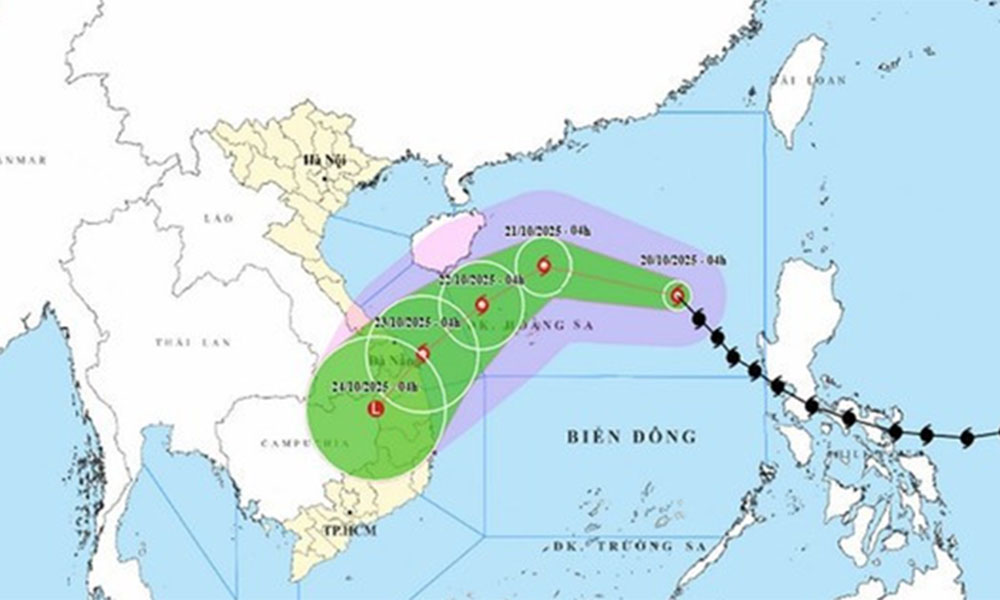
The movement of Typhoon Fengshen as of 5:00 on October 20. |
At 4:00 on October 20, the storm’s centre was located at 17.5 degrees North latitude and 117.2 degrees East longitude, about 540 km northeast of Hoang Sa special zone.
The strongest winds near the storm’s centre were at level 9 (75 – 88 km/h), with gusts reaching level 11. The storm was moving northwestward at about 25 km/h.
By 4:00 on October 21, the storm is forecast to be about 180 km north-northeast of Hoang Sa, with maximum wind speeds at levels 10 – 11, gusting up to level 13, moving west-northwest at around 20 km/h and likely to strengthen further.
By 4:00 on October 22, it will be located about 180 km northwest of Hoang Sa, maintaining level 10 – 11 winds, gusting to level 13, and moving southwestward at around 10 km/h.
Affected areas include the western part of the northern East Sea (including Hoang Sa) and the waters off Thua Thien-Hue to Quang Ngai provinces. Disaster risk is expected to be be at level 3.
By 4:00 on October 23, the typhoon is expected to be in the waters from Thua Thien-Hue to Quang Ngai, with winds decreasing to level 8, gusting up to level 10, moving southwestward at about 10 km/h and likely to weaken further.
In the following 72 to 96 hours, Fengshen is expected to move mainly southwestward at about 10 km/h, gradually weakening into a tropical depression.
Due to its impact, the northern East Sea (including Hoang Sa) will experience strong winds of levels 7 – 8, increasing to levels 9 – 11 near the storm’s centre, with gusts up to level 13. Wave heights will range from 3 – 5 metres, peaking at 5 – 7 metres near the storm’s core, causing very rough seas.
All vessels operating in or near the affected areas are at risk from thunderstorms, whirlwinds, strong winds, and high waves.
On mainland, Fengshen’s circulation, combined with a cold air mass, easterly disturbances, and orographic effects, is expected to bring widespread and prolonged heavy rainfall from Ha Tinh to Quang Ngai provinces between October 22 and 27, with some areas likely to experience extremely heavy rain, posing a high risk of flash floods and landslides in mountainous regions.
Local authorities are urged to prepare response plans for possible flooding at or above level 3 on rivers from Quang Tri to Quang Ngai.
On October 19, the Head of the National Civil Defence Steering Committee issued an official dispatch to the people’s committees of coastal provinces and cities from Quang Ninh to Lam Dong, and to the Ministries of National Defence, Public Security, Agriculture and Environment, Construction, Industry and Trade, Foreign Affairs, Science and Technology, as well as the Vietnam News Agency, Vietnam Television, and the Voice of Vietnam, urging them to take proactive measures in response to the typhoon.
The committee requested authorities to closely monitor the storm’s developments, strictly manage vessels going out to sea, prepare rescue forces and equipment, and enhance communication to ensure timely updates on the storm’s progress are delivered to local administrations, vessel owners, and residents to proactively respond.
 Bắc Ninh


Reader's comments (0)