 Bắc Ninh

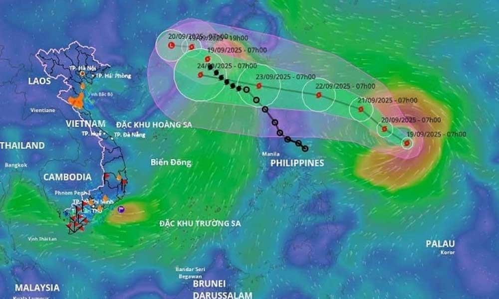
Storm Ragasa forecast to become super typhoon with 201 kph winds before entering East Sea
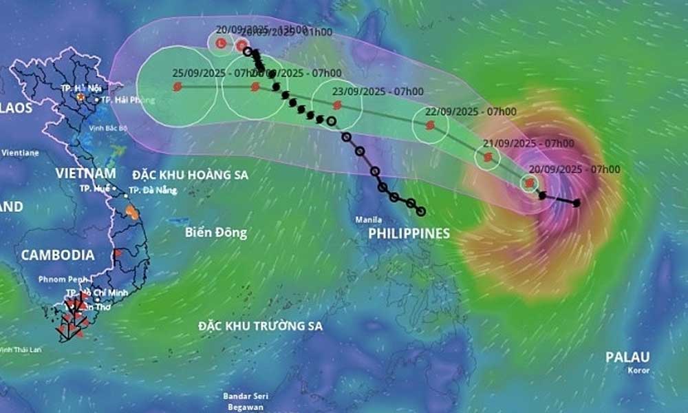
Storm Ragasa is intensifying and is forecast to strengthen into a super typhoon with peak winds of 201 kph over the next two days, before moving into the East Sea.
The storm was about 600 km east of Luzon Island in the Philippines on Sunday morning, packing maximum winds of 149 kph, moving northwest at 10–15 kph, according to Vietnam's National Center for Hydro-Meteorological Forecasting.
 |
|
Storm Ragasa's forecast path as of Sept. 20, 2025. |
By Monday morning, it is forecast to be about 240 km from Luzon, packing winds of up to 183 kph and tracking west-northwest at around 15 kph, with further strengthening expected.
At 1 a.m. on Tuesday, the storm is expected to be over waters north of Luzon, with maximum winds of 201 kph, maintaining its direction and increasing forward speed to 15–20 kph.
After that, Ragasa will enter the East Sea. By 1 a.m. on Wednesday, it is forecast to be about 140 km southeast of Hong Kong.
The Vietnamese meteorological agency projects that on Thursday next week the storm will cross China’s Leizhou Peninsula with winds of 167–183 kph, weakening to 118–133 kph as it moves into the Gulf of Tonkin.
The Japan Meteorological Agency forecasts Ragasa will reach its peak intensity as it passes Luzon into the East Sea, with winds of 198 kph, before approaching China’s coast and entering the Gulf of Tonkin with winds near 108 kph.
The Hong Kong Observatory similarly expects the same track, but says the storm’s maximum intensity on Tuesday could reach 220 kph. It forecasts Ragasa will still sustain winds of about 145 kph near the Leizhou Peninsula.
Due to the storm’s influence, the northeastern South China Sea, which Vietnam calls the East Sea, is expected to face strong winds, and waves up to 8 meters high, threatening vessels operating offshore.
Vietnam's National Civil Defense Steering Committee has requested provinces from Quang Ninh to Lam Dong to closely monitor developments, notify ships at sea, and prepare search-and-rescue forces.
So far this year, the South China Sea has recorded eight storms and two tropical depressions. Most recently, Storm Mitag hit China on Saturday without direct impacts on Vietnam.
The seventh storm, Tapah, did not directly strike Vietnam but brought heavy rain and landslides to northern mountainous provinces early this month. On Aug. 30, Storm Nongfa slammed into central Vietnam with winds of 62–74 kph, cutting off mountain communities in Ha Tinh, Quang Tri and Nghe An.
Meteorologists warn that from October to December, the South China Sea could see more storms than average, with over four expected in the final quarter, nearly half of which may make landfall.


Reader's comments (0)