 Bắc Ninh


Tropical depression heads toward northern Vietnam, expected to gain strength
A tropical depression east of China's Hainan Island is forecast to move into the Gulf of Tonkin, where it could strengthen and bring rough seas to the region starting Friday.
The National Center for Hydro-Meteorological Forecasting reported the system was located east of Hainan Island at 7 a.m. on Thursday.
 |
|
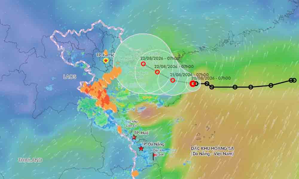
The predicted trajectory of a tropical depression near the Gulf of Tonkin. |
It was moving west at 5 to 10 kph, sustaining maximum winds of 49 kph with gusts up to 74 kph.
Forecasts indicate the system will maintain its westward trajectory and speed over the next 24 hours, positioning its center over northern Hainan Island.
Its intensity is expected to remain steady as it crosses the island, packing sustained winds of 39 to 49 kph and gusts reaching up to 74 kph.
By 7 a.m. on Saturday, the depression is expected to slow to around 5 kph and shift west-northwest, centering over the waters east of the Gulf of Tonkin.
Meteorologists warn the system could strengthen over the gulf, generating sustained winds of 50 to 61 kph and gusts between 75 and 88 kph.
Over the subsequent 48 to 72 hours, the depression is projected to continue moving west-northwest at a slower pace of 3 to 5 kph.
Winds over the eastern Gulf of Tonkin will gradually intensify starting Aug. 21. Sustained winds will reach 39 to 61 kph with gusts up to 88 kph, whipping up waves between two and three meters high.
The National Civil Defense Steering Committee has urged local authorities, ministries, and agencies to closely monitor the depression and strictly manage offshore maritime traffic.
Since the start of the year, the East Sea (internationally known as the South China Sea) has recorded two major storms.
On July 1, a tropical depression formed over the central sea and strengthened into Typhoon Maysak.
As the first storm of the year, Maysak generated sustained winds of 75 to 88 kph and gusts up to 117 kph. It made landfall in Quang Ninh Province, home to Ha Long Bay, on the evening of July 4, packing winds of up to 74 kph.
On July 23, another depression strengthened into Typhoon Noul, the year's second storm off Vietnam's coast. It moved toward Guangdong, China, bypassing the Vietnamese mainland.
The meteorological agency anticipates that tropical storm and depression activity over the East Sea will remain broadly in line with long-term averages from July through September.

































Reader's comments (0)