 Bắc Ninh

Why Super Typhoon Ragasa intensifies and weakens quickly
Super Typhoon Ragasa intensified at an unusually fast pace because it formed over a wide stretch of warm sea with surface temperatures of 29–30 C, and it is set to weaken just as rapidly after encountering a dry air mass moving down from the north and friction from land.
Ragasa developed last Thursday from a tropical depression off the coast of the Philippines. Within just three days, it strengthened by eight categories to become a super typhoon.
 |
|
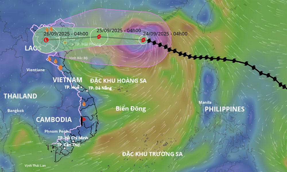
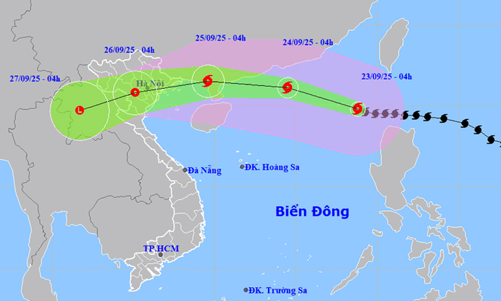
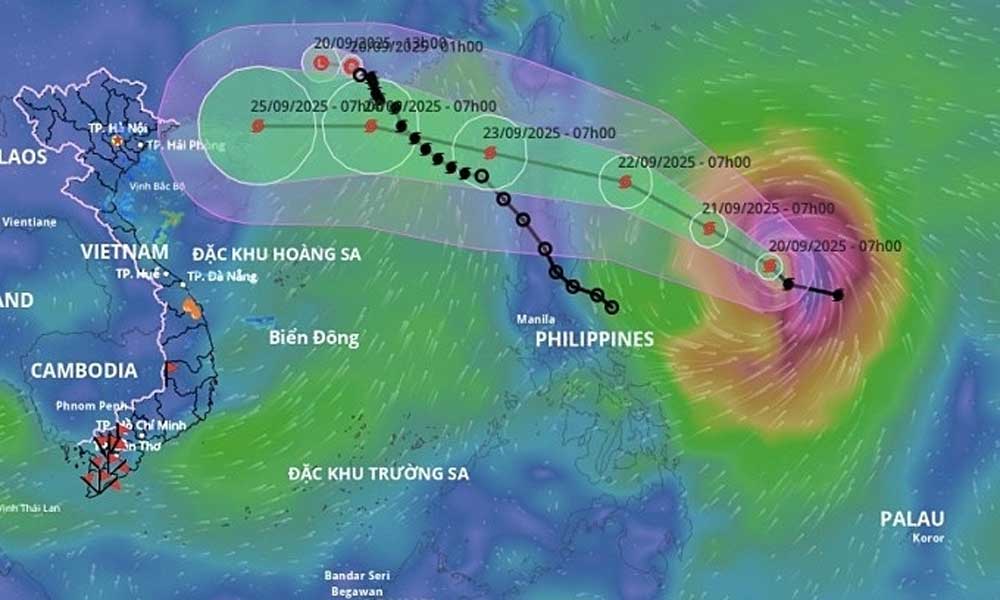
The trajectory of Super Typhoon Ragasa. |
By Monday evening, as it entered the East Sea (South China Sea), Ragasa peaked with sustained winds of 221 km per hour.
It surpassed Typhoon Yagi of 2024, making it the strongest system recorded in the sea in the past 70 years.
One day after entering the East Sea, Ragasa weakened by one level on Tuesday evening, packing winds of 167-201 kph and has maintained that level until Wednesday morning.
At 6 a.m. on Wednesday, it lay 380 km east of China's Leizhou Peninsula. Over the next three hours, the typhoon is expected to move west-northwest at about 20 kph, according to the National Center for Hydro-Meteorological Forecasting.
By 4:00 a.m. Thursday, the storm will be over waters off China's Guangxi coast, about 150 km east of Mong Cai Town of Quang Ninh, Vietnam. It is expected to make landfall in Quang Ninh – Hai Phong around noon on Thursday with wind speeds of 61-88 kph.
Truong Ba Kien, Deputy Director of the Center for Meteorology and Climate Research at the Institute of Meteorology, Hydrology and Climate Change, pointed to several contributing factors to the storm's rapid intensification and weakening.
The storm formed in the western Pacific and tracked northwest between the Philippines and Taiwan, traveling over open waters without interacting with land or islands.
"In this area, sea surface temperatures stayed consistently at 29–30 C. The warm, deep water layer provided abundant energy for the storm to strengthen," he said.
He added that other atmospheric conditions also favored rapid intensification. Weak vertical wind shear in the upper atmosphere, which means sudden changes in wind speed or direction with altitude, allowed the storm's structure to remain symmetrically stable.
Meanwhile, low-level convergence (drawing warm, moist air into the storm's center) combined with upper-level divergence (pushing that air upward) created efficient ventilation, fueling further intensification.
From a dynamics perspective, Kien explained that the storm was situated within a region of large-scale cyclonic circulation and strong convergence, which enhanced convection and concentrated momentum into the storm's core.
At the same time, its center lay on the southwestern edge of the subtropical high, producing a stable steering flow that enabled Ragasa to strengthen continuously without drifting off course or dispersing energy.
During this process, Ragasa also underwent an eyewall replacement cycle - a phenomenon where the dense cloud ring surrounding the center is replaced by a new one.
This led to the formation of a larger, rounder, and more defined eye, with smaller internal vortices that concentrated winds more effectively and pushed maximum wind speeds higher.
"Thanks to these favorable thermodynamic and dynamic conditions, Ragasa reached its peak intensity at Category 17 during the mature stage of its life cycle, when its structure was at its most developed, symmetrical, and stable," he said.
After peaking on Monday night, Ragasa maintained its strength before showing signs of weakening by midday Tuesday.
At 10 a.m. on Tuesday, the super typhoon was located over the northern East Sea with sustained winds of 184-221 kph, and moving west-northwest at 20 kph. This indicates the weakening process began earlier than forecast by Vietnam's meteorological agency.
Mai Van Khiem, director of the National Center for Hydro-Meteorological Forecasting, said several factors would cause Ragasa to weaken rapidly in the coming days, focusing on two major reasons.
The first is the presence of a continental high-pressure system to the north, carrying a dry air mass with humidity of just 30-40%, moving southward.
The entire northern side of the storm will be affected by this dry air mass. Dry intrusions will penetrate the storm's structure, causing it to weaken as it moves into the waters near Guangdong Province and Leizhou Island on Wednesday," Khiem explained.
The second factor, he said, is that over the next two to three days Ragasa will track farther north, bringing it into greater contact with the terrain of mainland China, where friction will weaken the storm. Vietnam’s meteorological agency has also been working with Japan to test AI-based forecasting, combining outputs from international models.
"So far, all forecasts agree that Ragasa will move north of Leizhou Island, unlike Yagi, which passed farther south and was less affected by land friction," Khiem noted. He added that tropical cyclones typically have a lifespan of five to seven days, with maximum strength occurring around the third or fourth day.


Reader's comments (0)