 Bắc Ninh

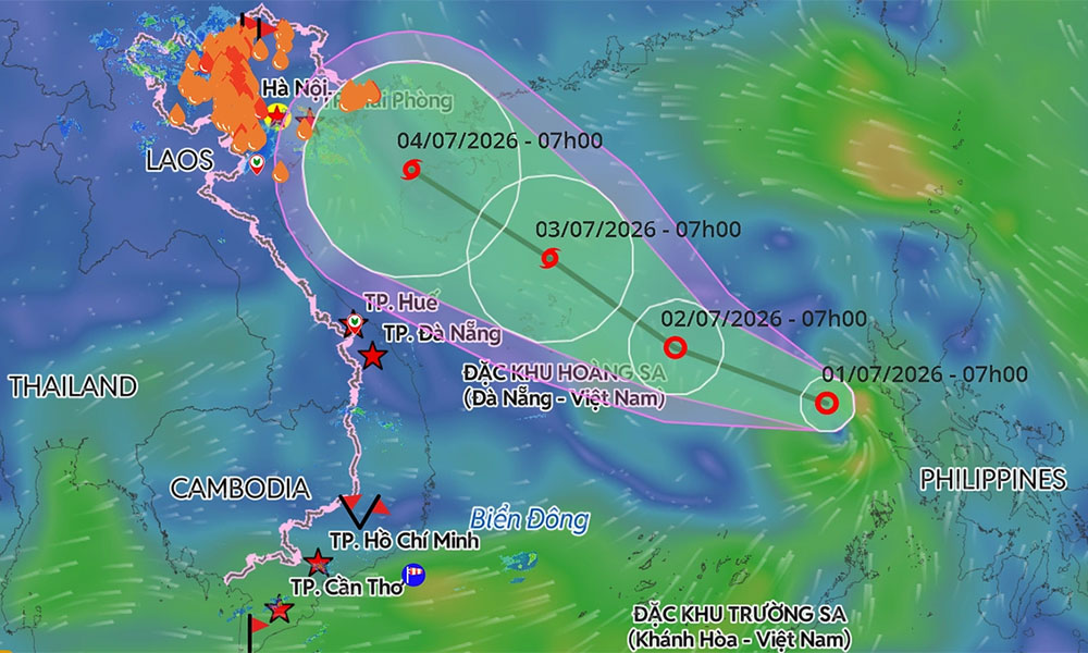
Storm Maysak forms off Vietnam's coast, may hit Ha Long Bay area
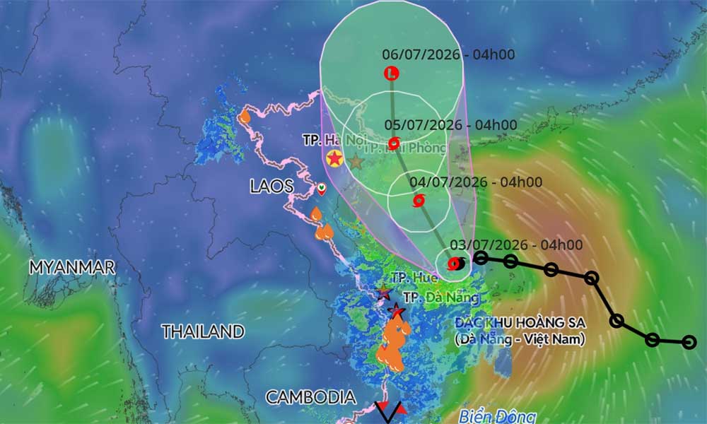
A tropical depression over the northwestern waters of the Paracel (Hoang Sa) Islands strengthened into Storm Maysak early Friday, threatening to bring heavy rainfall to northern Vietnam.
According to the National Center for Hydro-Meteorological Forecasting, the storm lay centered 110 km southeast of China's Hainan Island at 4 a.m. Friday. It was packing maximum sustained winds of 74 kph, with gusts of 89–102 kph, and moving northwest at 10–15 kph.
 |
|
A predicted trajectory of a tropical depression that has strengthened into Storm Maysak in the East Sea. |
Forecasters said Maysak is expected to continue tracking north-northwest over the next 24 hours, passing west of Hainan Island. By early Saturday, it is forecast to remain over the island's western region with little change in intensity.
The storm is expected to enter the Gulf of Tonkin by early Sunday before approaching the coast between Quang Ninh and Hai Phong, home to Ha Long Bay and other popular coastal attractions. It will then move into China's Guangxi Province, where it is forecast to weaken into a tropical depression on Monday.
Meteorological agencies in Japan and Hong Kong also predict the storm will maintain winds of around 65 kph over the Gulf of Tonkin before strengthening to about 72 kph as it nears the Vietnam-China border.
The storm is expected to bring deteriorating weather conditions across northern coastal waters. From Friday night, winds in the Gulf of Tonkin will strengthen to 39–61 kph, increasing to 62–74 kph with gusts of up to 102 kph near the storm's center. Wave heights are forecast at 2–4 m, while coastal areas from Quang Ninh to Hung Yen could see waves of 2–3 m.
The weather agency warned that strong winds, rough seas and elevated water levels could threaten ships, aquaculture facilities, sea dikes and other coastal infrastructure.
From Saturday afternoon, coastal localities from Quang Ninh to Hung Yen are forecast to experience sustained winds of 39–49 kph, rising to 50–74 kph. Northeastern Vietnam could also be hit by thunderstorms, squalls and wind gusts of up to 74 kph.
Heavy rain is forecast from Friday night through Sunday across northeastern Vietnam and Thanh Hoa Province. Rainfall totals are expected to reach 100–200 mm, increasing to 150–250 mm in parts of the northeast, with isolated areas likely to receive more than 350 mm.
The National Civil Defense Steering Committee has instructed coastal provinces from Quang Ninh to Khanh Hoa to closely monitor vessels at sea, warn them to avoid dangerous waters and ensure the safety of residents and tourists in coastal and island areas. Rescue forces have been placed on standby as authorities intensify monitoring and emergency preparedness.
Only one tropical depression had formed in the East Sea before Maysak this year, and it posed no threat to Vietnam.
The weather agency forecasts around five tropical storms and depressions will develop over the East Sea between June and August, close to the long-term average, with about two expected to directly affect Vietnam. Storm activity from September to December is forecast to be below average due to El Niño conditions.
Despite the expected decline in the number of storms later this year, forecasters cautioned that localized torrential rain, flash floods and landslides remain a significant threat, particularly in the mountainous regions of northern and central Vietnam.
The East Sea recorded 21 tropical storms and depressions in 2025, the highest annual total since records began in 1961.
Natural disasters that year left 484 people dead or missing and caused economic losses exceeding VND104.7 trillion (US$4 billion), making it one of Vietnam's costliest years on record for disaster damage.


Reader's comments (0)