 Bắc Ninh

Typhoon Kalmaegi to affect central Vietnam today, landfall expected sooner
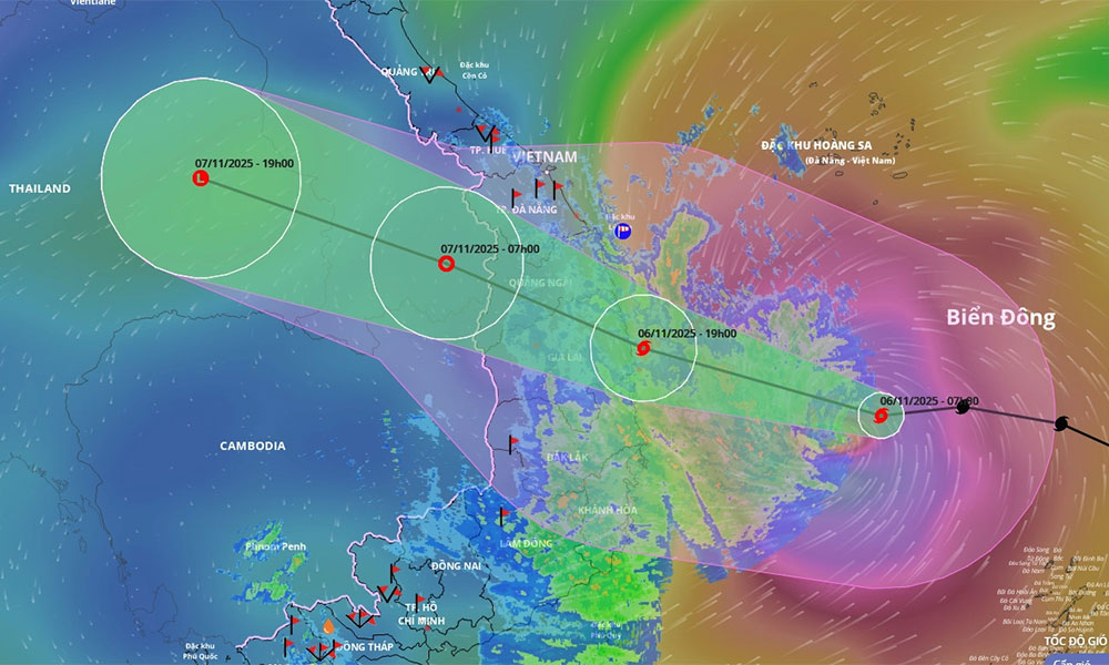
Mainland areas from Da Nang to Dak Lak will experience strong winds of up to 133 kilometers per hour from Thursday afternoon as Typhoon Kalmaegi moves toward south central Vietnam.
The National Center for Hydro-Meteorological Forecasting (NCHMF) reported that at 9 a.m. Thursday, the storm lay center around 290 km from Quy Nhon Ward of Gia Lai Province, packing maximum sustained winds of 167–183 kph, tracking west-northwest at 20–25 kph.
 |
|
The trajectory of Typhoon Kalmaegi. |
By 4 p.m., the center would be within 120 km east of Quy Nhon, with winds still near 150–166 kph.
Landfall across the Quang Ngai–Gia Lai region is now anticipated between 7–8 p.m. Thursday, several hours earlier than previously forecast, with winds expected to reach 118–133 kph.
The NCHMF director, Mai Van Khiem, warned that the storm's fast movement ensures strong winds will significantly affect inland areas in both Gia Lai and Quang Ngai.
By 4 a.m. Friday, the storm is forecast to be positioned over Vietnam and Laos border, with winds weakening to 75–88 kph. Kalmaegi is then expected to rapidly weaken into a tropical depression and ultimately a low-pressure system over eastern Thailand.
Winds across the southern East Sea, from Quang Tri to Khanh Hoa (including Ly Son and Cu Lao Cham Islands), began intensifying Thursday morning from 39–49 kph to a damaging 150–166 kph, churning up waves of 3–9 meters.
On land, southern Da Nang to Dak Lak will face winds of 39–61 kph, escalating to 61–133 kph from Thursday afternoon. Northern Quang Tri to northern Da Nang and northern Khanh Hoa will experience winds up to 61 kph.
Coastal areas from Hue to Dak Lak have been instructed to prepare for storm surges, high waves, coastal flooding in low-lying areas, and beach erosion, all of which may severely hamper drainage efforts.
Meteorologists have predicted extreme rainfall across the Central Region and Central Highlands.
Da Nang, Quang Ngai, Gia Lai, and Dak Lak are forecast to receive 200–400 mm of rain on Thursday and Friday, with some areas potentially exceeding 600 mm. Southern Quang Tri to Hue, Khanh Hoa, and Lam Dong will see 150–300 mm, with some locations surpassing 450 mm. Heavy rainfall is expected to gradually decrease from Nov. 8.
The downpours are likely to raise water on local rivers, some beyond the third warning level, the highest.
Truong Ba Kien, deputy director of the Center for Meteorology and Climatology at the Vietnam Institute of Meteorology, Hydrology and Climate, stated that while the total rainfall may be less than the recent historic event that caused widespread flooding in Hue and Da Nang from late October, the risk of localized flooding, flash floods, and landslides remains very high due to saturated soil and weak ground conditions.
He warned that if the storm slows near the coast, rainfall could increase drastically, leading to major floods along local rivers.
Local authorities from Da Nang to Khanh Hoa have responded by closing seas, calling fishing boats back to shore, lowering reservoir levels for flood preparation, hastily harvesting aquaculture, and reinforcing homes. Airlines have canceled or adjusted flights to airports in the central region and the Central Highlands, including Tuy Hoa, Phu Cat, Chu Lai, and Buon Ma Thuot.


Reader's comments (0)